6- days mount kilimanjaro rongai route
À PROPOS DE L'ITINÉRAIRE DE RONGAI
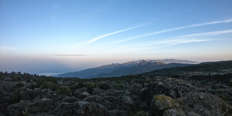
La route de Rongai est la seule route qui s'approche du Kilimandjaro par le nord, près de la frontière kenyane. Bien que de plus en plus populaire parmi les grimpeurs, cet itinéraire est toujours peu fréquenté. Rongai a une pente plus progressive que les autres itinéraires de la montagne. C'est l'itinéraire préféré de ceux qui recherchent une alternative à l'itinéraire populaire de Marangu, de ceux qui souhaitent une randonnée plus éloignée et de ceux qui grimpent pendant la saison des pluies (le côté nord reçoit moins de précipitations). Rongai est un itinéraire modérément difficile et est fortement recommandé, en particulier pour ceux qui ont moins d'expérience en randonnée.
L'itinéraire s'approche du mont Kilimandjaro par le sud, en commençant par un court trajet en voiture de Moshi à Machame Gate. Le chemin mène les randonneurs à travers la forêt tropicale jusqu'au plateau de Shira. Ici, de nombreuses routes du Kilimandjaro convergent. Ensuite, la route tourne vers l'est et traverse sous le champ de glace sud du Kilimandjaro sur un chemin connu sous le nom de circuit sud avant de culminer depuis Barafu. La descente se fait par la voie Mweka.
Détails
Bon a savoir
Elevation: 6,398 ft to 9,300 ft
Distance: 8 km/5 miles
Hiking Time: 3-4 hours
Habitat: Rain Forest
>>> We drive from Moshi to Marangu Gate for permits before taking a short transfer to the Rongai Gate trailhead. The path winds through corn and potato fields and then climbs gently through the forest which is home to a variety of wildlife, including the black and white colobus monkey.Elevation: 9,300 ft to 11,300 ft
Distance: 6 km/4 miles
Hiking Time: 3-4 hours
Habitat: Heath
Second Cave to Kikelewa Cave
Elevation: 11,300 ft to 11,811 ft
Distance: 6 km/4 miles
Hiking Time: 3-4 hours
Habitat: Heath
We begin this morning with a steady incline up to Second Cave. We continue trekking through moorland, leaving the main trail for a smaller path towards the jagged peaks of Mawenzi, before finally arriving at Kikelewa Cave for the night.Elevation: 11,811 ft to 14,160 ft
Distance: 5 km/3 miles
Hiking Time: 3-4 hours
Habitat: Alpine Desert
>>> The hike today is short and steep up a grassy slope. Views of the wilderness area are stunning. As we exit the heath zone and emerge into the Alpine Desert zone, the landscape changes dramatically. Our camp is situated beneath the jagged spires of Mawenzi, at Mawenzi Tarn. The remainder of the day can be spent relaxing or exploring the area.On a good firm path, you will cross the Saddle today. You will feel the altitude and might experience symptoms of altitude sickness – headache and nausea? Takes lots of fluid and keeps going very slowly. You will hear your guide say pole – slowly. One last tough section and you will be there. You will camp at School Hut tonight, but not before some dinner and hot chocolate. Get your daypack ready and go to bed early as you will be woken up at around 00:00 to start the final stretch to the summit.
Elevation (ft): 15,430 ft to 19,341 ft
Distance: 6 km/4 miles
Hiking Time: 6-8 hours
Habitat: Arctic
Uhuru Peak to Horombo Hut
Elevation (ft): 19,341 ft to 12,250 ft
Distance: 16 km/10 miles
Hiking Time: 4-5 hours
Habitat: Heath
Very early in the morning (around midnight), we begin our push to the summit. This is the most mentally and physically challenging portion of the trek. The wind and cold at this elevation and time of day can be extreme. We ascend in the darkness for several hours while taking frequent, but short, breaks. At Gilman’s point (18,600 ft), you will be rewarded with the most magnificent sunrise you are ever likely to see coming over Mawenzi Peak. Finally, we arrive at Uhuru Peak- the highest point on Mount Kilimanjaro and the continent of Africa.After spending a few moments taking in the plains of Africa and your accomplishment, we descend to Horombo Hut. Later in the evening, we enjoy our last dinner on the mountain and a well-earned sleep.Elevation (ft): 12,205 ft to 6,046 ft
Distance: 20 km/12 miles
Hiking Time: 5-7 hours
Habitat: Rain Forest
On our last day, we have a long trek mostly downhill through the tropical rainforest. Once at the park headquarters at Marangu gate, we collect our summit certificates. A vehicle will meet us here and drive us back to the hotel in Moshi.
Point de rencontre
MOSHI
Dates disponibles à venir
Organisé par
EMMANUEL KITANO

We organize wildlife safaris ( Serengeti, Ngorongoro, Lake Manyara, Tarangire, Arusha National Park, ) we organize KILIMANJARO / MERU Mountain Climbing. We organize beach holidays in Zanzibar we organize TOURS around Lake Victoria.


